7 More Kentucky Hikes with Amazing Views
State Wide
When people talk about scenic hikes in Kentucky, the discussion often focuses on the steep slopes of the Daniel Boone National Forest, and rightfully so. But, you can find great views throughout the state, from the waterfront trails at Land Between the Lakes to the high crags of Kingdom Come State Park in the east. In the past we’ve highlighted some of the most scenic treks in the Bluegrass State, but we’ve unearthed seven more hikes with their own spectacular views.
LICK FALLS OVERLOOK, GRAYSON LAKE STATE PARK
The lake and golfing are big draws for Grayson Lake State Park, but be sure to leave half a day on the itinerary for the hike to Lick Falls Overlook. During spring, or after a good rain, you’ll catch the falls in all their glory, as a curtain of water meets with a broad pool set in a rocky alcove. If you begin at the park amphitheater, you can do a moderate 3-mile loop to visit the falls, and in early spring you’ll get some nice views of Grayson Lake along the way. If you begin at the park campground, you can reach the falls via the the 0.8-mile Beech-Hemlock Trail, which intersects the Lick Falls Loop. On the Beech-Hemlock Trail hikers can investigate interesting sandstone formations along the lakeshore, including Lizard Head Rock.
RAVEN ROCK TRAILS, KINGDOM COME STATE PARK
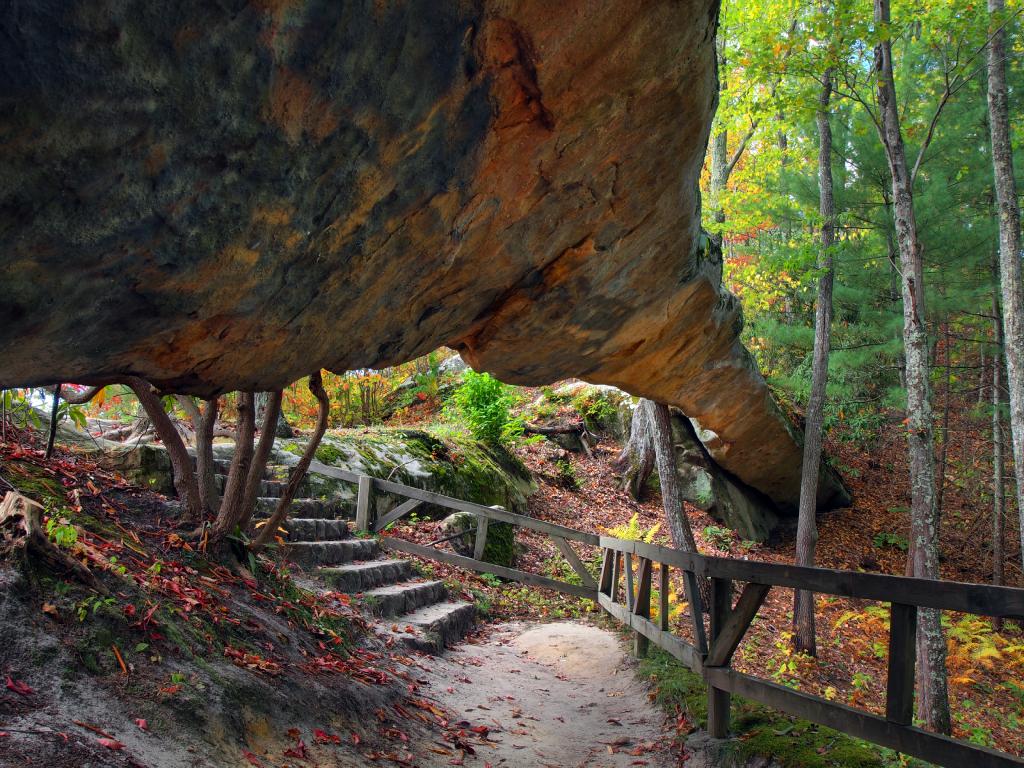
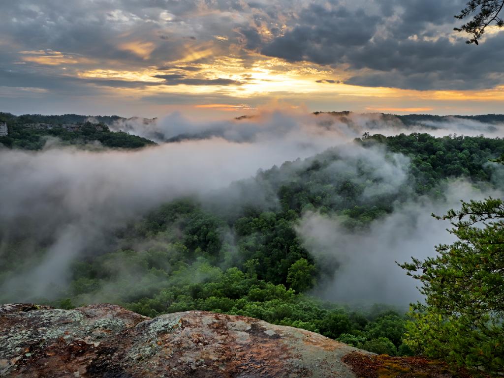
If Kingdom Come State Park is the crowning jewel along the crest of Pine Mountain, Raven Rock is the shiniest gemstone. Multiple trails in the park lead to the Raven Rock perch, which rewards hikers with stunning views of Black Mountain and the Cumberland River Valley. For a short but intense 1-mile (one way) hike to Raven Rock, connect the Pine and Powerline trails. When you reach the Powerline Trail, a series of switchbacks takes you to the top of Raven Rock, which is an immense formation of exposed stone that rises 290 feet and sits at a 45-degree angle. As you explore this park you’ll notice that its unusual geology creates an intriguing landscape, with scattered jumbles of sandstone and limestone bedrock.
SILTSTONE TRAIL, JEFFERSON MEMORIAL FOREST
On the southern outskirts of Louisville, the Siltstone Trail in Jefferson Memorial Forest hits area high points, including Pine Top, High Knob, Flint Knob and Circle Knob. Rated moderate to difficult, the Siltstone Trail includes plenty of ups and downs to challenge hikers. Because it’s a difficult path that measures 12.1 miles, you need to plan your hike carefully to determine how far you can realistically hike and whether you need to place a car at your end point to avoid a lengthy return. During summer, a dense canopy of leaves provides shade on the trail, but it also blocks some of the views, so you should consider hiking in spring or late fall. To access to the Siltstone Trail, begin at the Tom Wallace Welcome Center or along Bearcamp and Scotts Gap roads. The Scotts Gap Loop, at the southwestern end of Siltstone, gives you an additional 3.3-mile loop option in the area.
GREEN RIVER BLUFFS TRAIL, MAMMOTH CAVE NATIONAL PARK
You can take any number of trails to loop back to the visitor’s center. While Mammoth Cave National Park is primarily known as the home of world’s longest cave system, it also includes an extensive collection of trails. The Green River Bluffs Trail takes you on a 1.3-mile walk where you’ll spend much of the time skirting the Green River and enjoying good views of this beautiful stream. For the most part, the terrain is gentle, though you’ll encounter a brief series of steep switchbacks that ascend bluffs along the river, and also climb a half-mile through attractive open forest. You can take any number of trails to loop back to the visitors center, thus stretching the miles and the views of your outing.
INDIAN BLUFF & PENNYRILE NATURE TRAILS, PENNYRILE FOREST STATE RESORT PARK
If you’re an ambitious hiker, you might want to do the entire Pennyrile Nature Trail, which stretches more than 13 miles through Pennyrile Forest State Resort Park, Pennyrile State Forest and Tradewater Wildlife Management Area. But, just about everyone can hike to the nice views you encounter within the first few miles of the path. Beginning at the Indian Bluff Trailhead near the lodge parking lot, you’ll head uphill and link to the Pennyrile Nature Trail, which weaves between the front and back nine of the golf course and skirts scenic bluffs and overlooks. It’s best to do this hike in spring or fall, as the Pennyrile Nature Trail has uneven footing and can be overgrown in the summer.
CHIMNEY TOP ROCK, DANIEL BOONE NATIONAL FOREST
Don’t expect solitude on this popular hike in the Daniel Boone National Forest, north of Pine Ridge, Kentucky. But, the crowds don’t take anything away from the view as you peer into the Red River Gorge and surrounding valleys. A great hike for people of all ages, the 0.6-mile round-trip walk is really more of a stroll and follows a paved path. Sandstone pillars at the end of the trail offer many places to pause and take in the surrounding landscape, which is especially attractive when wildflowers bloom in spring, and when the foliage turns in the fall. When you visit, be sure to check out Princess Arch, which shares a trailhead parking lot with Chimney Top Rock.
HONKER TRAIL, LAND BETWEEN THE LAKES NATIONAL RECREATION AREA
This easy to moderate 4.5-mile trail in the Land Between the Lakes National Recreation Area circles Honker Lake and explores dense upland and bottomland forest. Along the way, you’ll not only enjoy great views of the lake but you can also spy a rich array of birds and other wildlife. Dating back to the 1930s, the Civilian Conservation Corp constructed Honker Lake to manage waterfowl habitat, and it has also served as a relocation site for beaver, river otter, and osprey. As you walk along the lake in the spring, you’ll see views of blooming lotus flowers in the water. Just keep in mind that the path can be a bit muddy and sloppy after rain.