Daniel Boone was an explorer and hero of American pioneer history, the preeminent symbol for America's westward movement across its first frontier.

The legendary frontiersman, Daniel Boone, first charted an early trail for other pioneers to follow into America's heartland during the spring of 1775. That trail came to be known as Boone Trace.


This was the first road, EVER, into the land that was to become Kentucky and started the Westward Movement when our country was first born. Today, you can see the inspiring sights that greeted Boone and his fellow travelers, as well as visit museums that help bring this vivid chapter of American history to life. Explore the map below to plan your journey through Kentucky's frontier days.
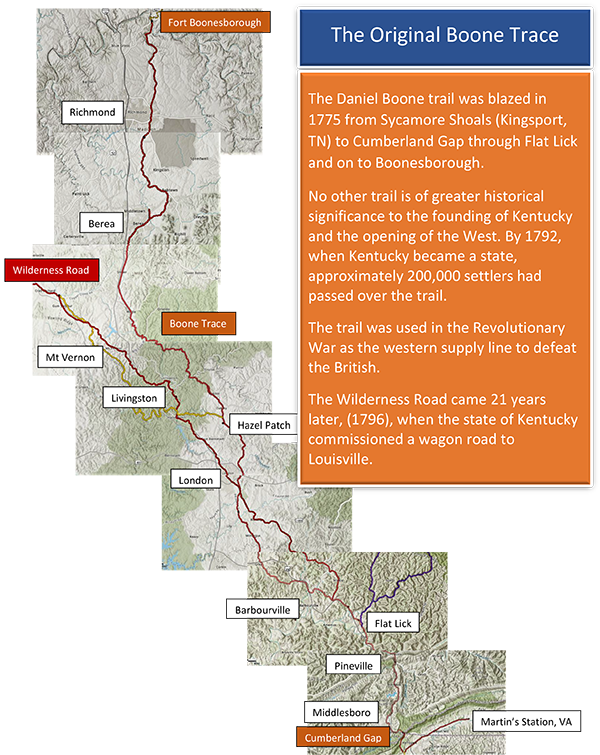
 

Boone Trace Map


That trail, which was only a bridle path extended from current-day Kingsport, TN, through the Cumberland Gap to Boonesborough. By the time Kentucky became a state in 1792, more than 200,000 settlers had passed over it, enduring severe hardships, including Indian attack, cold, and hunger. No other trail is of greater historical significance to the founding of Kentucky and the opening of the west than “that little road.” Combining Boone Trace of 1775 with the Declaration of Independence of 1776 was the beginning of the Westward Movement and the birth of our country as we know it today. We stopped being British and became Americans! And it comes right up through the heart of Kentucky! 


Below is the order of the cities of Boone Trace if traveling north.


Maps of the Auto Tour can be found at this LINK.

Cumberland Gap National Historical Park

“Daniel Boone and a party of fellow explorers were the first to venture through Cumberland Gap as they traveled from present day Kingsport, TN, in 1775, leading to the discovery of Kentucky and its creation as a state. Today, modern explorers can enjoy the park’s endless trails, scenic overlooks, outdoor activities and campgrounds.”


LEARN MORE

Middlesboro

Middlesboro came somewhat later in the evolution of the Trace. It was not officially founded until 1888 and was initially inhabited by Native Americans such as the Shawnee.


LEARN MORE

Pineville

Originally founded as Cumberland Ford, this town is now situated along Boone Trace and the Wilderness Road that Daniel Boone and early pioneers once traveled as they began their exploration west. Still largely unspoiled, the area welcomes visitors to enjoy its parks, golf courses, music festivals and more.


LEARN MORE

Flat Lick

Flat Lick is an unincorporated community south of Barbourville and can be entered off of US 25E and on to Evergreen Rd. Boone Trace is slightly east of the road at this point having traversed “Pogue Hollow” on to Sandy Branch Rd. It is the oldest community in the county, settled before 1784, and named for a large salty area which attracted wild animals. 


LEARN MORE

Barbourville

Barbourville was founded in 1800, and to settlers upon passing through the Cumberland Gap in those days, it became the largest and most progressive population center south of Richmond by 1812.


LEARN MORE

London

The city of London began as a settlement along the Wilderness Road in 1826 long after Boone Trace had come through the area in 1775. 


LEARN MORE

Livingston

The city of Livingston does not lie on Boone Trace (BT) but allows access to it. The auto route of Boone Trace departs from the actual trail route at Trace Branch Rd along Hwy 490 if traveling north, passes through Mount Vernon, and rejoins the Trace at the little town of Wildie. When passing through Livingston, it joins the Wilderness Road along Hwy 25 into Mount Vernon which will continue westward along Hwy 150 to Fort Harrod and ultimately to Louisville, known as the Falls of the Ohio in pioneer times.


LEARN MORE

Mount Vernon

Mount Vernon, like Livingston, is not on Boone Trace(BT) but gives access to the Trace, since no rural roads run near, or even parallel to it. However, it is on the Wilderness Road(WR) via Highways 25 & 150 and has it own interesting features and place in the history of the Westward Movement.


LEARN MORE

Berea

Berea is a town on Boone Trace known for its arts and crafts festivals, historic restaurants and buildings and as the home of Berea College, the first in the Southern United States to be racially integrated as early as 1856.


LEARN MORE

Richmond

The city of Richmond is a significant population center along Boone Trace which enters the Bluegrass by way of Blue Lick Rd following Hays Fork Creek along Hwy 421 turning westward on Crooksville Rd (Hwy 499.)


LEARN MORE

Fort Boonesborough State Park

The final terminus of Boone Trace in 1775 was a site on the Kentucky River near the mouth of Otter Creek where a fort was constructed. A full scale replica of the fort, complete with living historians, is the parks main feature and located approximately 1/2 mile from the original fort site.  


LEARN MORE

Winchester/ Clark County

The nearest town on the northern end of Boone Trace is historic Winchester, KY located nine miles north of Fort Boonesborough on Highway 627 (Boonesboro Rd) and well-worth a visit.


LEARN MORE